Cambodia’s historic temples are some of the most impressive in the world, but last month it was revealed that Angkor Wat and other historic sites in the region represent just the tip of the iceberg. A recent archaeological survey, led by Damian Evans, used airborne LiDAR technology to reveal evidence of large cities and developments between 900 and 1,400 years old, hidden beneath the forest floor. We asked Peter Sharrock, on the south-east Asian board at the School of Oriental and African Studies (SOAS), to explain how these sorts of discoveries are made, and what their significance is for historians and for the country.

The helicopter during the 2015 flight operations, with the lidar instrument mounted within a pod on the right-hand skid. Photo: Francisco Goncalves
LiDAR now gives us clear data, for the first time, of dense populations settled in an around all ancient Cambodian temples at the capital Angkor and far beyond. This urban and rural landscape, linked by road and canal networks, now seems to have constituted the largest empire on earth in the 12th century. The LiDAR findings have already radically changed our conceptions about the size, complexity and importance of the ancient Khmer Empire. The new technology effectively lifts the forest to show the ancient settlements it has encroached upon and entirely obscured.
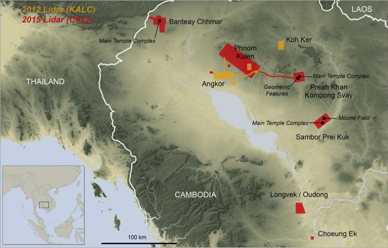
Overview map of Cambodia showing the main coverage blocks for the 2012 and 2015 ALS acquisitions, and noting features. Background elevation courtesy of NASA SRTM. Damian Evans / Journal of Archaeological Science
The LiDAR data, extracted from millions of laser particles dispersed from a helicopter-borne computer system, penetrates the tropical forest to its floor to uncover the traces of ancient settlements. This brings us an instant picture of the cities of the ancient empire that could not conceivably have been uncovered by conventional means of excavation. The new data sets a completely different ground plan for assessing the density and complexity of the empire that reached its height in the year 1200. Some of the data can be immediately interpreted as city centres and suburbs constructed in wood, but there are new formations on the forest floor that are so far not understood at all. The value of LiDAR is that it pinpoints the places where more conventional archaeological explorations may follow up to lead us to further discoveries.
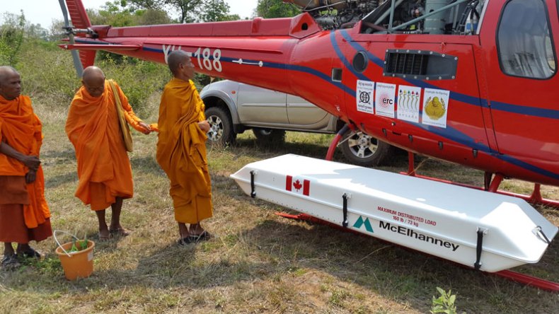
Buddhist monks preparing for a traditional blessing ceremony next to the helicopter and lidar instrument within its pod, at the remote temple complex of Banteay Chhmar. Photo: Damian Evans
The glorious past of Angkor, made more glorious today by LiDAR, is a psychological as well as historical boost of immeasurable importance to the Cambodian people, as they build their new historical position in contemporary Asia, with a massive new heritage-tourist industry, after the utter devastation of Pol Pot’s Khmer Rouge regime that devastated the country after the American war in Indochina and killed a quarter of the Cambodian population.
Damian Evans’ full findings are published in the Journal of Archaeological Science.
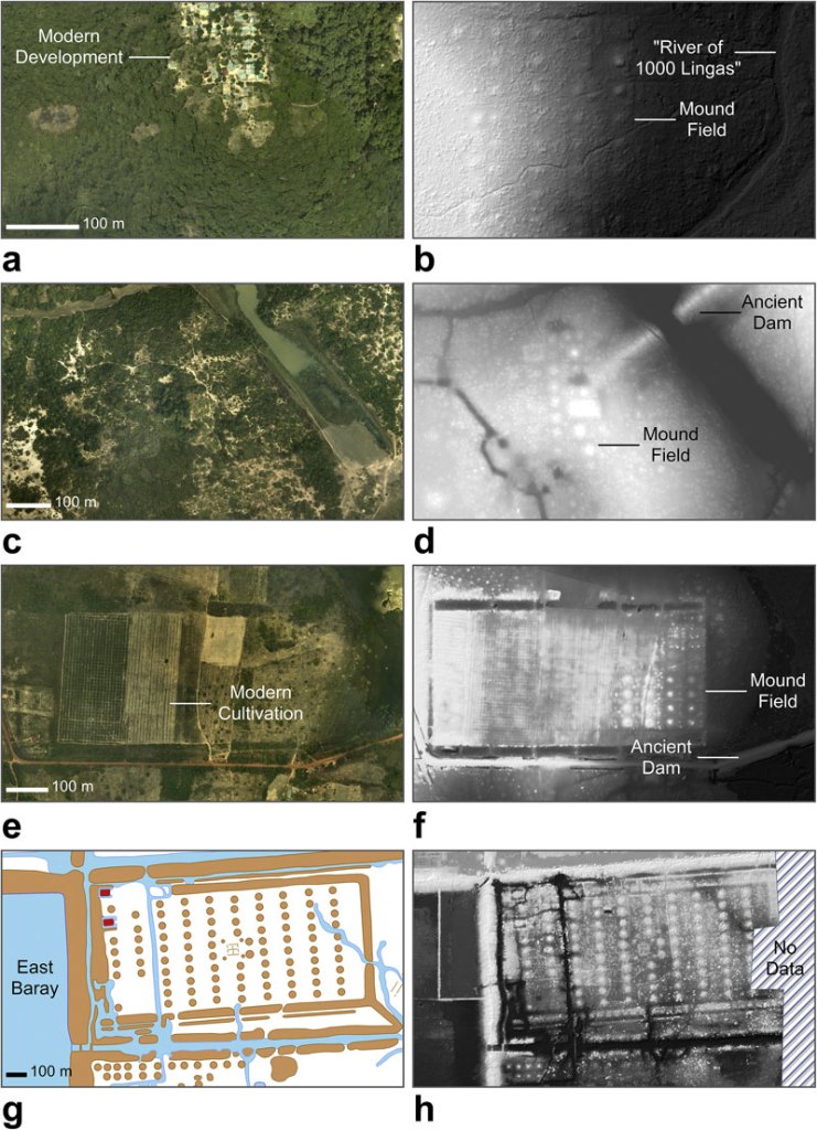
‘Mound fields’ across Cambodia. Panels 3a,b: In the Phnom Kulen acquisition block (see Fig. 2) in an area covered by modern development and forest (3a) the laser scanning data reveal a mound field (3b). Panels 3c,d: Immediately to the north of the main temple complex at Sambor Prei Kuk, vegetation (3c) obscures a mound field and an ancient dam (3d). Panels 3e,f: Immediately to the west of Banteay Srei temple at Angkor, cultivated areas and vegetation (3e) obscure – and have partially erased – a mound field of ∼8 ‘rows’ and ∼12 ‘columns’ (3f). Panels 3g,h: Near the exit of the East Baray reservoir at Angkor, new archaeological mapping (3g) based on the 2012 ALS data has added further detail to a ∼10 × 10 grid of mounds (3h) and revealed a second mound field to the south of the exit. Panels 3a,c and e are conventional aerial imagery acquired in the 2015 campaign. Panel 3g is based on archaeological maps by Damian Evans, Christophe Pottier and Pelle Wijker. Panels 3b,d,f and h are ALS-derived bare earth models with a histogram stretch, overlain by a semi-transparent hillshade model. Damian Evans / Journal of Archaeological Science


![Masterpiece [Re]discovery 2022. Photo: Ben Fisher Photography, courtesy of Masterpiece London](http://www.apollo-magazine.com/wp-content/uploads/2022/07/MPL2022_4263.jpg)

Airborne technology is revealing Cambodia’s extraordinary medieval history
The Angkor-period temple of Banteay Top, within the Banteay Chhmar acquisition block. Lidar revealed details of a large earthen enclosure and additional temple sites and occupation areas in the vicinity of this large stone temple. Photo: Damian Evans
Share
Cambodia’s historic temples are some of the most impressive in the world, but last month it was revealed that Angkor Wat and other historic sites in the region represent just the tip of the iceberg. A recent archaeological survey, led by Damian Evans, used airborne LiDAR technology to reveal evidence of large cities and developments between 900 and 1,400 years old, hidden beneath the forest floor. We asked Peter Sharrock, on the south-east Asian board at the School of Oriental and African Studies (SOAS), to explain how these sorts of discoveries are made, and what their significance is for historians and for the country.
The helicopter during the 2015 flight operations, with the lidar instrument mounted within a pod on the right-hand skid. Photo: Francisco Goncalves
LiDAR now gives us clear data, for the first time, of dense populations settled in an around all ancient Cambodian temples at the capital Angkor and far beyond. This urban and rural landscape, linked by road and canal networks, now seems to have constituted the largest empire on earth in the 12th century. The LiDAR findings have already radically changed our conceptions about the size, complexity and importance of the ancient Khmer Empire. The new technology effectively lifts the forest to show the ancient settlements it has encroached upon and entirely obscured.
Overview map of Cambodia showing the main coverage blocks for the 2012 and 2015 ALS acquisitions, and noting features. Background elevation courtesy of NASA SRTM. Damian Evans / Journal of Archaeological Science
The LiDAR data, extracted from millions of laser particles dispersed from a helicopter-borne computer system, penetrates the tropical forest to its floor to uncover the traces of ancient settlements. This brings us an instant picture of the cities of the ancient empire that could not conceivably have been uncovered by conventional means of excavation. The new data sets a completely different ground plan for assessing the density and complexity of the empire that reached its height in the year 1200. Some of the data can be immediately interpreted as city centres and suburbs constructed in wood, but there are new formations on the forest floor that are so far not understood at all. The value of LiDAR is that it pinpoints the places where more conventional archaeological explorations may follow up to lead us to further discoveries.
Buddhist monks preparing for a traditional blessing ceremony next to the helicopter and lidar instrument within its pod, at the remote temple complex of Banteay Chhmar. Photo: Damian Evans
The glorious past of Angkor, made more glorious today by LiDAR, is a psychological as well as historical boost of immeasurable importance to the Cambodian people, as they build their new historical position in contemporary Asia, with a massive new heritage-tourist industry, after the utter devastation of Pol Pot’s Khmer Rouge regime that devastated the country after the American war in Indochina and killed a quarter of the Cambodian population.
Damian Evans’ full findings are published in the Journal of Archaeological Science.
‘Mound fields’ across Cambodia. Panels 3a,b: In the Phnom Kulen acquisition block (see Fig. 2) in an area covered by modern development and forest (3a) the laser scanning data reveal a mound field (3b). Panels 3c,d: Immediately to the north of the main temple complex at Sambor Prei Kuk, vegetation (3c) obscures a mound field and an ancient dam (3d). Panels 3e,f: Immediately to the west of Banteay Srei temple at Angkor, cultivated areas and vegetation (3e) obscure – and have partially erased – a mound field of ∼8 ‘rows’ and ∼12 ‘columns’ (3f). Panels 3g,h: Near the exit of the East Baray reservoir at Angkor, new archaeological mapping (3g) based on the 2012 ALS data has added further detail to a ∼10 × 10 grid of mounds (3h) and revealed a second mound field to the south of the exit. Panels 3a,c and e are conventional aerial imagery acquired in the 2015 campaign. Panel 3g is based on archaeological maps by Damian Evans, Christophe Pottier and Pelle Wijker. Panels 3b,d,f and h are ALS-derived bare earth models with a histogram stretch, overlain by a semi-transparent hillshade model. Damian Evans / Journal of Archaeological Science
Unlimited access from just $16 every 3 months
Subscribe to get unlimited and exclusive access to the top art stories, interviews and exhibition reviews.
Share
Recommended for you
Ghost House
Rachel Whiteread’s ‘House’ was unveiled 20 years ago today. It stood for barely three months, but its influence endures
Why collect only women artists?
Valeria Napoleone discusses her unusual collection, and the importance of her relationships with artists
The Art Fund’s shortlist for Museum of the Year has been announced
The nominees range from small local museums, to a 100-acre outdoor museum and one of the UK’s biggest institutions