
There’s been a glut of map-related exhibitions in London recently, but this small free exhibition at the Oxo Tower makes a fine diversion. Tightly curated, it offers a sort of ‘greatest hits’ of London cartography, showcasing the chart-toppers from John Rocque and Harry Beck to Stephen Walter.
The small scale is a plus: it allows you to really rub your nose against the glass and absorb the detail that makes maps so fascinating, like the deer sunning themselves in the fields of what is now Fitzrovia in a delightful map by Georg Braun and Frans Hogenberg from 1574, or the copy of John Rocque’s great Georgian map from 1768 that includes the legend ‘place where soldiers are shot’ at Speakers’ Corner.
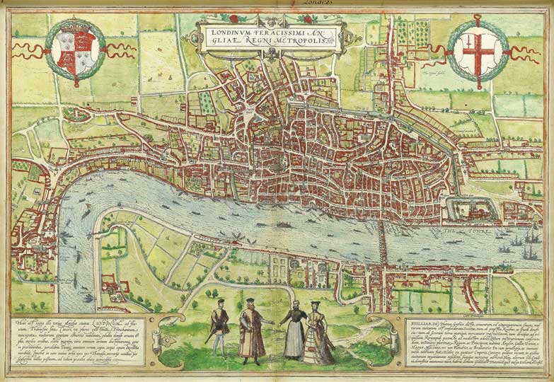
The Earliest Extant Plan of London (1574), Braun and Hogenberg. Courtesy Daniel Crouch Rare Books
The maps were acquired by Daniel Crouch Rare Books from a private collection, and include rarities such as a unique copy of Thomas Porter’s c.1655 map, originally published for ‘Countrey-men and strangers’ and a Georgian map printed on a fan.
For £16,000 you can get a gargantuan Rocque from 1751–1754, printed on 16 sheets and mounted on linen. It shows London as an island, surrounded by fields that would be under concrete within 100 years, carefully subdivided by surveyors who worked in acres, furlongs, chains and rods – one rod, 16ft 6in, being the size of the front of a typical London house. The ghost of London’s future – packed terraces of squat Victorian houses – can therefore be seen in the borders of suburban fields on these Georgian maps.
, John Rocque. Courtesy Daniel Crouch Rare Books")

Opposite Rocque’s huge work is John Ogilby and William Morgan’s house-by-house map of the City from 1676. It’s a forensic piece of draughtsmanship but doesn’t catch the breath like the majestic Rocque, which really demands close study. And the intimacy of the exhibition means it’s possible to get down on your knees – or on tiptoes, depending on where you live – to find your own street or nearest landmark; on GF Cruchley’s 1828 map, my local pub can be seen, disconcertingly located alongside a farm.
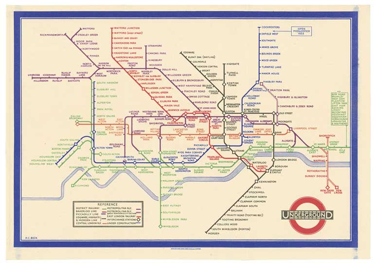
A trio of more recent maps rounds things off, starting with Harry Beck’s pristine Tube map from 1933, followed by two commissioned by the London Transport Museum for a recent exhibition. Simon Patterson’s Saptarishi is a cover version of his The Great Bear, which reimagined Beck’s map, replacing station names with saints, footballers and philosophers, and spawning a million tiresome mash-ups.
More fulfilling is Stephen Walter’s London Subterranea, a ‘dark’ version of his The Island, which saw London covered with scribbled notes describing how Walter understood or experienced each locale. London Subterranea does the same for London’s underbelly mapping sewers, crypts and lost rivers, but also brothels and murder sites. With white type on a black background, it’s not the most legible of creations for something that must be read rather than observed, but in the relative calm of the gallery, it can easily occupy your attention for an engrossing, dislocating, 20 minutes.
, Simon Patterson. Commissioned by the London Transport Museum. Courtesy Daniel Crouch Rare Books")
, Stephen Walter. TAG Fine Arts 2012. Courtesy Daniel Crouch Rare Books")
‘Mapping London’ is at gallery@oxo, Oxo Tower Wharf, London until 14 September. Hosted by Daniel Crouch Rare Books, it is part of the Totally Thames Festival.
Unlimited access from just $16 every 3 months
Subscribe to get unlimited and exclusive access to the top art stories, interviews and exhibition reviews.


![Masterpiece [Re]discovery 2022. Photo: Ben Fisher Photography, courtesy of Masterpiece London](http://www.apollo-magazine.com/wp-content/uploads/2022/07/MPL2022_4263.jpg)
It’s time for the government of London to return to its rightful home