Over the course of lockdown in London, I have learned almost exactly how many steps it is from Shadwell to St Paul’s. I can tell you which pavements are widest, which alleys quietest, and where the sun collects in the early evening. I have become acquainted with the saints and satyrs clinging to the city’s stone facades; the sculptures standing watch in secluded squares; the shop mannequins stuck in last season’s clothes. Little details, once hidden in plain sight – such as the uneven finish of the windows on old guild halls or the ghost signs on warehouse walls – have quietly revealed themselves. Walking the empty streets during a devastating pandemic was not the introduction to Tower Hamlets and the City that I anticipated when I moved here in January. But it has been an effective one and, in the midst of so much uncertainty, a welcome one.
There is much talk of lockdown ushering in a virtual age, of online learning, digital museums and screen-based social lives, but this is also a period of intense physical awareness as each of us is forced to rethink our interactions, redraw our boundaries and reconsider what it means to occupy and share a space. While it is difficult to have the scope of daily life shrink so dramatically, those very limitations are helping many of us to rediscover the worlds on our doorsteps and wonder how they, and we, came to be there. The more I notice the shape, surface and sights of my immediate environment, the more I want to know its secrets. I know I am not alone in this: I’ve never seen so few people on the streets of London, but neither have I seen so many stopping, taking photos, reading plaques, looking up and around with fresh attention and time to spare.
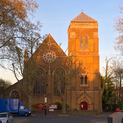
The City of London in spring 2020. Photo: the author
How can we cling on to this sense of place as life picks up pace again, as the streets fill with cars and people and our minds fill with familiar distractions? How can we help each other not just to look but to learn about our local areas?
My instinct, more often than not, is to turn to the internet for information. Wikipedia does a good enough job for the bigger landmarks, while more specialised websites such as The Watercolour World (a map of topographical watercolours, where I work as head of content and operations), Layers of London (a repository of historical maps, records and community stories) and Art UK (which is creating a complete online showcase of the nation’s public sculpture) offer fascinating cultural details, stories and facts. But accessing such information online takes time, attention and connectivity that is not often available when we’re on the move. You also need to know that such tools exist, and how to find them: for example, I only discovered Survey of London’s excellent Histories of Whitechapel tool while researching this article and following a tip from a former editor of Londonist.
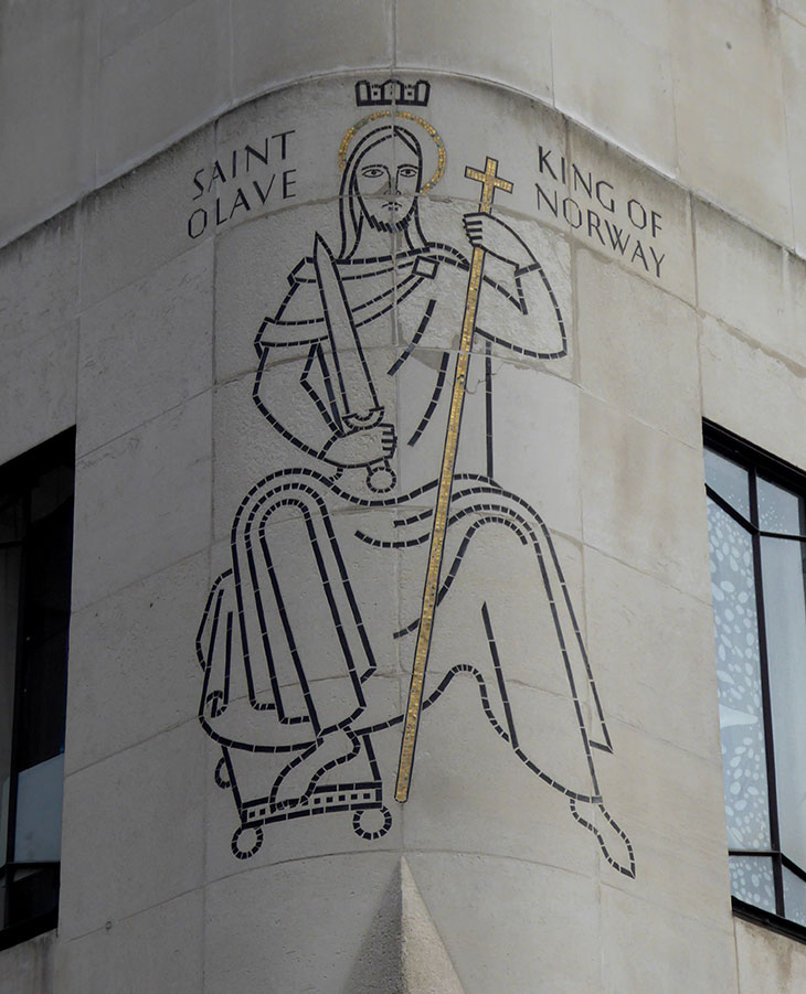
One alternative is to inscribe information into the physical environment itself. If you look closely you’ll find plenty of history written quite literally in stone. St Olaf House, part of London Bridge Hospital on Tooley Street, features on its facade a mosaic of the canonised King Olaf II of Norway and an inscription, engraved in a Nordic-inspired sans-serif type, about St Olave’s Church. The church, we are told, was founded in the 11th century and rebuilt twice, in the 18th and 19th centuries, before its demolition in 1928. How many modern constructions do the same? The new building was constructed between 1928 and 1932 to the art deco design of Harry Stuart Goodhart-Rendel and the mosaic is the work of the modernist artist Frank Dobson – but there’s no inscription for that. St Olaf House, along with its adornments, has slowly become a historical artefact itself.
The mosaic designed by Frank Dobson on the exterior of St Olaf House in London. Photo: Ethan Doyle White (CC BY-SA 4.0)
Other schemes aim to disperse information more lightly through a community. In 2017, the Norwood Society encouraged the owners of Victorian-era shop fronts in the Norwood Triangle to display unofficial blue plaques listing the names of previous occupiers. As part of its First World War centenary commemorations, Islington Council installed 400 small signs honouring the local war dead on the streets where they once lived. These types of projects tend to be one-offs, arranged by local and often informal groups on a limited budget. They are easy to install and engage plenty of people in the process, but without continued efforts the information they provide can fall out of date or into disrepair, or be taken down. Of course, this is also true of digital projects, which need maintenance as much as any plaque. But digital information is, in theory, at least a little easier to keep updated.
I would welcome hybrid solutions, in which physical signposts allow passers-by to access more detailed information online. A few of the unofficial blue plaques around London have QR codes – why not all of them? Apps like Shazam and Smartify help users identify the music and fine art they encounter in their daily lives – could one be created for buildings and monuments? Sing London’s ‘Talking Statues’ scheme invites people to scan a nearby tag with their smartphone and receive, in response, a phone call from the sculpted figure scripted and voiced by well-known writers and actors. That sort of quick and playful interaction makes exploring history a fun distraction rather than a studious task. Are there other ways to gamify local history in a way that catches on? The popularity of Geocaching (where participants use GPS to discover hidden containers in public areas) and Pokemon Go (an augmented reality game where players interact with virtual characters in the ‘real world’) certainly suggests a strong public appetite for treasure hunt-style activities. Or could physical signs – at bus, train and tube stations, for example – be flagged up somehow on Google Maps, so people stumble upon them as they travel?
Perhaps the most important thing is remind people to slow and stop, to look around from time to time, even when circumstances no longer prompt it. One way to do so is through art. Good public art can impart a sense of strangeness to familiar scenes and intervene in routine thoughts. Richard Wilson’s Slice of Reality (2000) is a good example. This weathered segment of the Arco Trent, a 240ft-long ocean-going sand dredger on the banks of the Thames by the O2 arena has been sliced open vertically. The habitable spaces inside are revealed exposed to the elements and the hull fills up with water every rising tide. Wilson envisaged it as a ‘lament to the lost industry’ of London’s docklands. It was commissioned as part of the North Meadow Sculpture Project to mark the new millennium, but functions as a marker of the past. Today, it is the eighth sculpture on The Line, a public sculpture trail whose online map also includes details of local heritage sites and wildlife, illustrated with pictures from various archives and museum collections. A minute’s walk away on the same route is Thomson & Craighead’s Here (2013), a simple road sign that points 24,859 miles along the Greenwich meridian and back to itself. Such pieces command attention and, once they have it, direct that attention outwards to their surroundings, or back on to the viewer. Art asks questions of the world around it; it sees and navigates things differently, just as we have all been learning to this spring.
One of the 12 installations comprising Culture Mile’s Around the Corner, installed in 2019. Photo: Odera Okoye
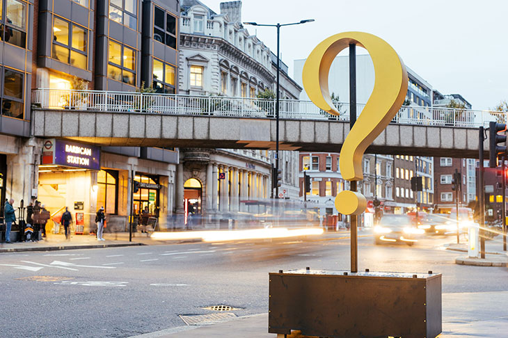
Covid-19 is a global crisis but it is also seven billion local events. With our physical and virtual lives so much in flux, and with so much of normal life under revision, many people have found comfort in their local communities and are awake for the first time to the history and character of their area. Last week, I finally got round to following another of London’s sculpture trails end to end. The Culture Mile, commissioned by the City of London Corporation and installed by the creative studio KHBT last year, consists of a series of large sculpted words strung like beads on a necklace around St Paul’s and up Aldersgate to Farringdon. Together, they form a single sentence from Jacob’s Room by Virginia Woolf: ‘What are you going to meet if you turn this corner?’ It’s a question I hope people keep asking, even after these days of strange and isolated excursions are over.